






- MMC chief puts Ghatkesar civic works on fast track
- Congress hits back at KTR over Sonia’s role in TG formation
- Sridhar Babu rolls out red carpet for Mumbai investors
- Telangana will oppose AP’s 1.8 TMC Nagarjuna Sagar water plan: Uttam
- BRS vows fight until all eligible get pensions
- GHMC sets target of 3,400 new Self-Help Groups
- GHMC to crack down on roadside dumping
- Kids below 12 can't use lifts alone in Maha
10 models fail to track precisely: Akvan keeps veering from forecast course
In Short
- Uncertainty over landfall spot on Andhra coast
- 10 weather models produce differing tracks
- Ichchapuram currently in projected path
- Srikakulam to Bapatla stretch faces extremely heavy rain
- Govt mobilises 24 NDRF, SDRF teams

Share :
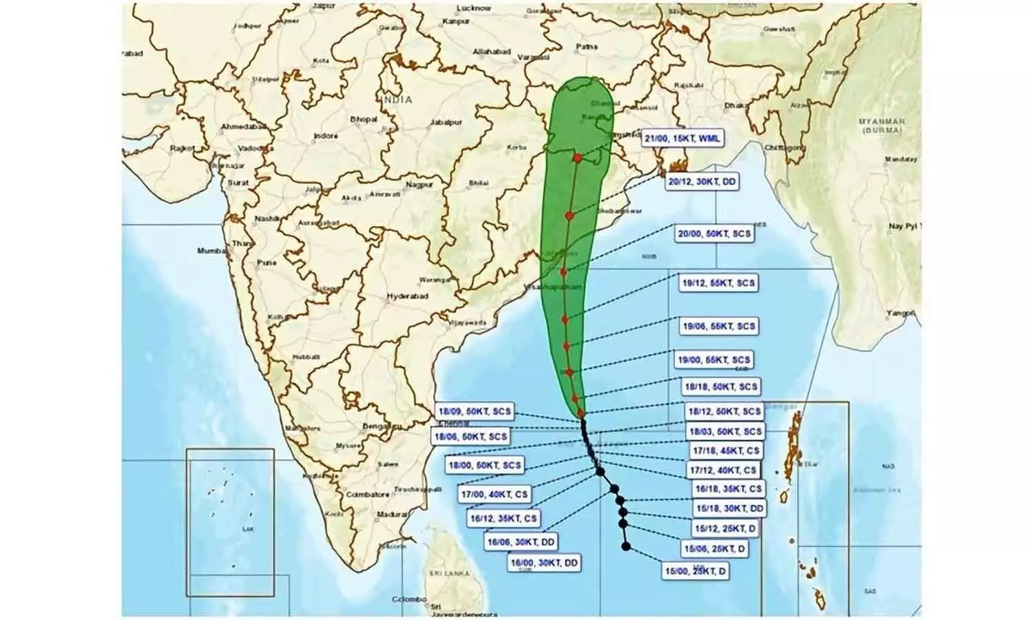
Akvan keeps veering from forecast course
Amaravati: Cyclone Akvan is keeping meteorologists guessing by continually changing its direction over the Bay of Bengal, with no finality among nearly 10 weather forecasting models on its eventual track. The rapidly shifting atmospheric conditions have made it difficult to pinpoint the landfall spot, even as the system intensified into a severe cyclonic form and started moving towards the Andhra Pradesh–Odisha coast.
The unusual feature of the developing cyclone is the frequency with which its projected trajectory has been changing. Meteorological officials said atmospheric dynamics were shifting every two to three hours, resulting in significant differences between morning and afternoon forecasts. Artificial Intelligence-based systems, global numerical weather prediction models, and high-resolution models are all indicating different tracks. High-pressure zones, or ridges, on either side of the projected path are also influencing the system's movement, forcing it to alter its direction.
The current forecast indicates a northerly movement towards the Ichchapuram area, with landfall likely between Narsapur and Puri by Friday afternoon. However, officials cautioned that the actual crossing point could shift within the forecast margin of error. The system is expected to remain over the sea for another two days, gradually approaching the coast.
Currently located over the west-central Bay of Bengal and adjoining southern Bay waters, the cyclone has moved at around eight kmph during the past six hours.
It is approximately 520 km from Narsapur, 560 km from Chennai, 570 km from Kalingapatnam, 660 km from Gopalpur, and 720 km from Puri.
Meteorologists, who initially anticipated its intensification into a very severe cyclonic storm, now expect it to remain a severe cyclonic storm because oceanic heat potential and other atmospheric conditions are not sufficiently favourable for further intensification. It may also lose some intensity before crossing the coast. Nevertheless, wind speeds at landfall could reach 90-100 kmph, with gusts up to 110 kmph.
Rainfall threat remains unchanged despite possible weakening. The uncertainty over the landfall spot has not altered the rainfall forecast. Very heavy to extremely heavy rainfall is expected across coastal Andhra Pradesh, from Srikakulam to Bapatla, particularly on November 19 and 20. This means districts well beyond the eventual landfall area could face significant weather-related disruption. Danger Signal No. 3 has been issued for north Andhra ports, with warnings also issued for south coastal Andhra ports.
The state government has placed all departments on high alert for the next 48 hours. Home Minister V Anita, after reviewing preparedness and relief arrangements, directed officials to prioritise the protection of lives and property. Thirteen NDRF teams, 11 SDRF teams and local fire service units have been kept ready for immediate deployment. Residents in coastal areas have been advised to avoid unnecessary movement, while people in low-lying areas have been asked to shift to rehabilitation centres when directed by authorities. Farmers have also been cautioned to take precautions against heavy rain and strong winds.
Energy Minister Gottipati Ravi Kumar has directed the three DISCOMs to prepare for possible damage to electricity infrastructure along the Nellore-Visakhapatnam coastal belt. He ordered the advance stocking of poles, transformers and other equipment and mobilisation of repair personnel. Seeking additional manpower from Telangana, he has written to its Energy Minister for assistance. Drawing lessons from cyclones Arnab and Murasu, Ravi Kumar directed officials to restore damaged power infrastructure on a war-footing.
SP Unlikely to Give Congress More Than 25 Seats in UP
Fee Reimbursement: Lokesh counters Jagan with Rs 4,962 cr statement
YSRCP has no place in politics: CM Naidu
10 models fail to track precisely: Akvan keeps veering from forecast course
CM Revanth Reddy heads to BRS bastion for political showdown
Telangana committed to SCs, STs uplift: Ganesh


